
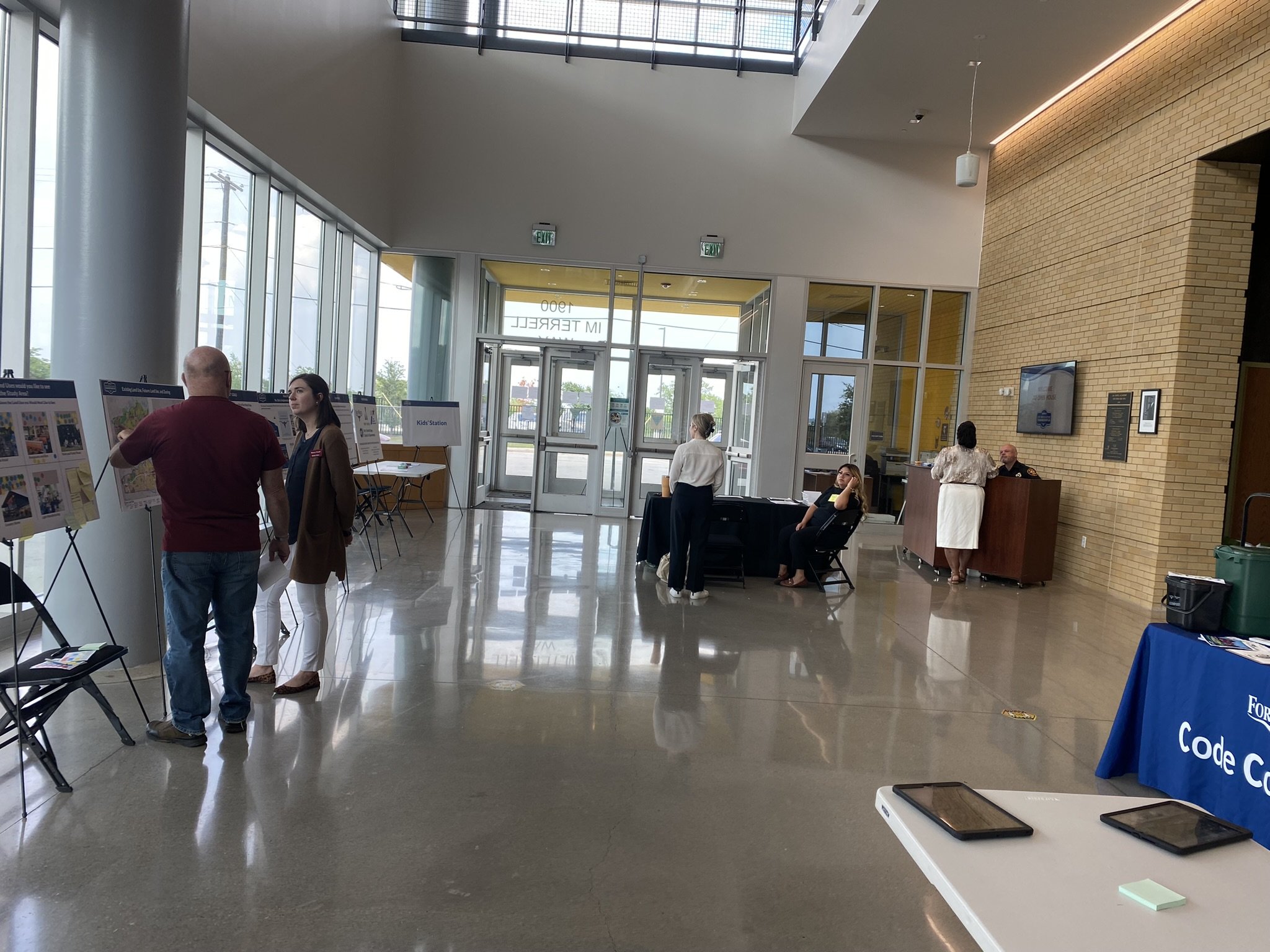
May 2023 Public Open House
Welcome Eastsiders!
Below is a virtual walk through of the information shared at our first series of public open houses.

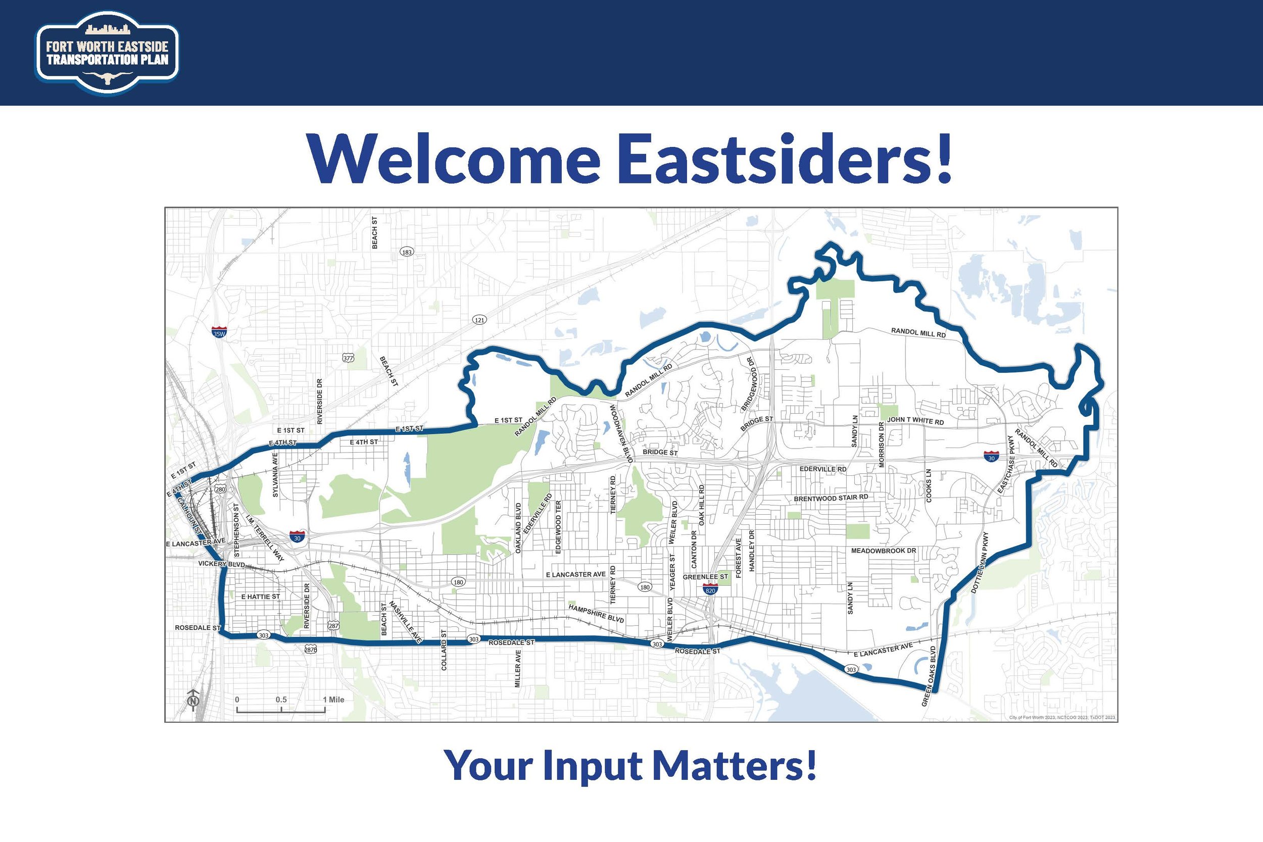
The project study area. / Área de estudio del proyecto.

Fort Worth Eastside Transportation Plan Project Partners. / Socios del proyecto del Plan de Transporte de Fort Worth Eastside

The board provides a summary of the overall purpose and anticipated outcomes of the Eastside Transportation Plan. Key plan features include safety improvements, housing and development strategies, and an alternatives analysis for East Lancaster Ave, Brentwood Stair Rd, and Bridge Street. / El tablero proporciona un resumen del propósito general y los resultados anticipados del Plan de Transporte de Eastside. Las características clave del plan incluyen mejoras de seguridad, estrategias de vivienda y desarrollo, y un análisis de alternativas para East Lancaster Ave, Brentwood Stair Rd y Bridge Street.

The board shows previously adopted planning studies and provides a foundation for the Eastside Transportation Plan. Summaries of each plan and how they impact the study area is provided in the Existing Conditions Report. / El tablero a muestra los estudios de planificación adoptados anteriormente que proporcionan la base para el Plan de Transporte de Eastside. Los resúmenes de cada plan y cómo impactan el área de estudio se proporcionan en el Informe de Condiciones Existentes.

The board summarizes the draft goals and objectives for the Eastside Transportation Plan. It also provides a space for stakeholders to provide comments on the draft goals. / El tablero resume el borrador de metas y objetivos para el Plan de Transporte del Este. También proporciona un espacio para que las partes interesadas proporcionen comentarios sobre los objetivos preliminares.

The board shows the existing zoning and current and future land uses for the study area. It also provides land use and zoning trends such the percentage of land in the study area used for residential and commercial uses. / El tablero muestra la zonificación existente y los usos de suelo actuales y futuros para el área de estudio. También proporciona tendencias de zonificación y uso del suelo, como el porcentaje de suelo en el área de estudio utilizado para usos residenciales y comerciales.

The board shows what different types of land uses that could be added to the study area and asks stakeholders to place a next to the land uses they would like to see added to the study area. Please take the project survey to tell us which land uses you would like to see in the study area. The short 2-minute survey is at the end of the presentation. / El tablero muestra los diferentes tipos de usos de la tierra que podrían agregarse al área de estudio y pide a las partes interesadas que coloquen una junto a los usos de la tierra que les gustaría ver agregados al área de estudio. Complete la encuesta del proyecto para decirnos qué usos de la tierra le gustaría ver en el área de estudio.

The board shows existing economic trends such as the number of jobs, types of jobs, and retail spending in the study area. / El tablero muestra las tendencias económicas existentes, como la cantidad de trabajos, los tipos de trabajos y el gasto minorista en el área de estudio.
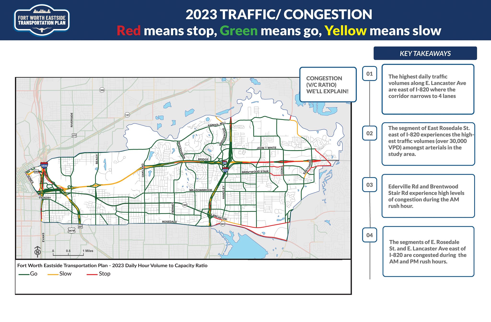
The board shows roadways that currently experience high levels of congestion. It also provide a summary of the times of day the roadways carry higher levels of traffic. Roadways currently experiencing high levels of congestion include East Lancaster Rd, East Rosedale St, Ederville Rd, Brentwood Stair Rd, and others. / El tablero muestra carreteras que actualmente experimentan altos niveles de congestión. También proporciona un resumen de las horas del día en que las carreteras tienen niveles más altos de tráfico. Las carreteras que actualmente experimentan altos niveles de congestión incluyen East Lancaster Rd, East Rosedale St, Ederville Rd, Brentwood Stair Rd y otras.

The board shows roadways that may experience high levels of traffic in the future. Roadways that may experience high levels of traffic congestion in the future include East Lancaster Rd, East Rosedale St, John T. White Rd, and others. / El tablero muestra carreteras que pueden experimentar altos niveles de tráfico en el futuro. Las carreteras que pueden experimentar altos niveles de congestión de tráfico en el futuro incluyen East Lancaster Rd, East Rosedale St, John T. White Rd y otras.

The board provides a summary of the traffic crashes in the study area. It includes areas with high concentrations of crashes and roadways listed on the City’s high-injury network. / El tablero proporciona un resumen de los accidentes de tránsito en el área de estudio. Incluye áreas con altas concentraciones de choques y carreteras que figuran en la red de alta tasa de lesiones de la ciudad.

The board summarizes transit ridership in the study area, including the number of transit trips taken per day and the amount of time it takes people to get where they are going using transit. / El tablero resume la cantidad de pasajeros del transporte público en el área de estudio, incluida la cantidad de viajes de transporte público realizados por día y la cantidad de tiempo que les toma a las personas llegar a donde van utilizando el transporte público.

El tablero resume la cantidad de pasajeros del transporte público en el área de estudio, incluida la cantidad de viajes de transporte público realizados por día y la cantidad de tiempo que les toma a las personas llegar a donde van utilizando el transporte público.

This board summarizes travel trends in the study area, including the top places people travel to in the study area. It also shows the number of people using each type of transportation on weekdays. / Este tablero resume las tendencias de viaje en el área de estudio, incluidos los principales lugares a los que viaja la gente en el área de estudio. También muestra el número de personas que utilizan cada tipo de transporte entre semana.

The board summarizes the alternatives analysis process, which is a way for stakeholders to figure out how they would like to see East Lancaster look and feel in the future. The six (6) step process is used to create a list of reasonable possibilities for how the roadway may look. The list is then narrowed down based on screening criteria until a preferred alternative(s) is selected. / El tablero resume el proceso de análisis de alternativas, que es una forma para que las partes interesadas descubran cómo les gustaría que East Lancaster se viera y se sintiera en el futuro. El proceso de seis (6) pasos se utiliza para crear una lista de posibilidades razonables de cómo se verá la carretera. Luego, la lista se reduce según los criterios de selección hasta que se seleccionen las alternativas preferidas.
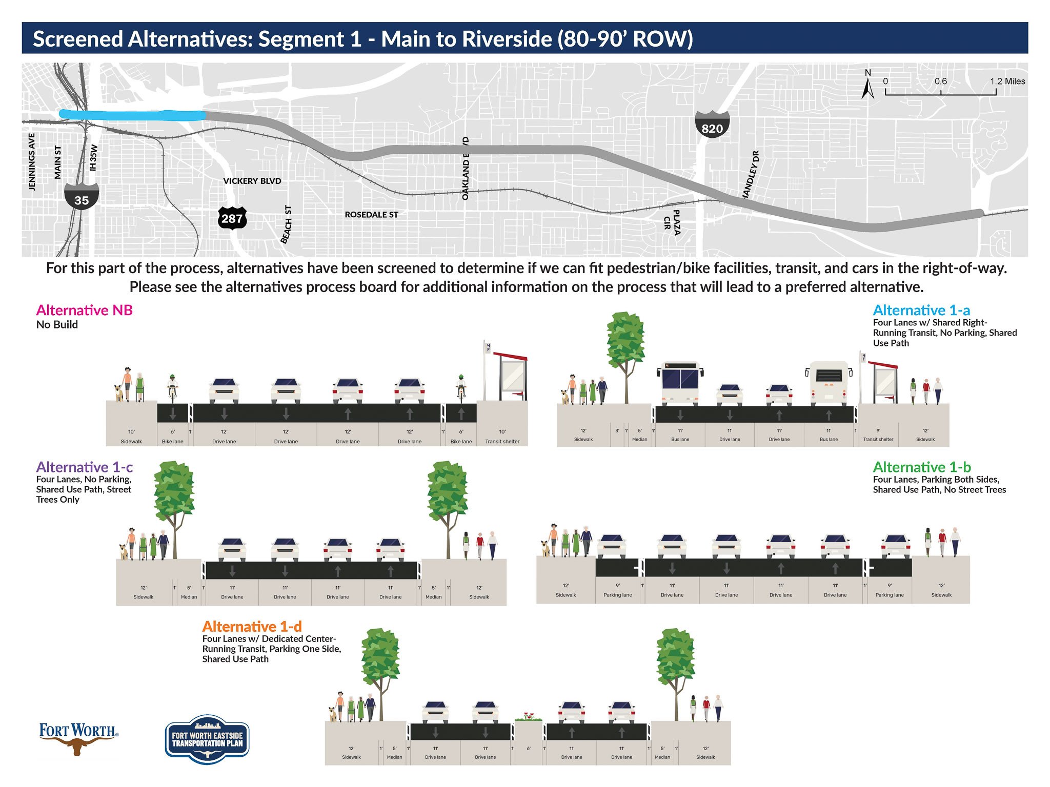
Board shows options for how the section of East Lancaster Ave. between Main Steet and Riverside Drive may look once a preferred alternative is identified during the final phase of the planning process. / El tablero muestra opciones sobre cómo se verá la sección de East Lancaster Ave. entre Main Steet y Riverside Drive una vez que se seleccione una alternativa preferida.

Board shows options for how the section of East Lancaster Ave. between Riverside Dr and I-820 may look once a preferred alternative is identified during the final phase of the planning process. / El tablero muestra opciones sobre cómo se verá la sección de East Lancaster Ave. entre Riverside Dr y la I-820 una vez que se seleccione una alternativa preferida.

Board shows options for how the section of East Lancaster Ave. between I-820 and Chilton St may look once a preferred alternative is identified during the final phase of the planning process. / El tablero muestra opciones sobre cómo se verá la sección de East Lancaster Ave. entre la I-820 y Chilton St una vez que se seleccione una alternativa preferida.

Board shows options for how the section of East Lancaster Ave. between Chilton St and Dottie Lynn Pkwy may look once a preferred alternative is identified during the final phase of the planning process. / El tablero muestra opciones sobre cómo se verá la sección de East Lancaster Ave. entre Chilton St y Dottie Lynn Pkwy una vez que se seleccione una alternativa preferida.

The board shows potential transit routes between East Lancaster Ave and the shopping centers at the intersection of I-30 and Eastchase Pkwy. The routes include an alignment along Handley Dr and Ederville Rd and an alignment along East Lancaster Ave and Eastchase Pkwy. / El tablero muestra posibles rutas de tránsito entre East Lancaster Ave y los centros comerciales en la intersección de la I-30 y Eastchase Pkwy. Las rutas incluyen una alineación a lo largo de Handley Dr y Ederville Rd y una alineación a lo largo de East Lancaster Ave y Eastchase Pkwy.

The board shows screening criteria used to narrow down the list of potential alternatives for East Lancaster Ave. Stakeholders were asked to place a sticker on the board to rate the importance of each item. / El tablero muestra los criterios de selección utilizados para reducir la lista de posibles alternativas para East Lancaster Ave. Se pidió a las partes interesadas que colocaran una calcomanía en el tablero para calificar la importancia de cada elemento.

The board shows a summary of walking conditions along Randol Mill Rd. It also includes a drawing of how the roadway may look in the future if sidewalks were built along Randol Mill Rd. / El tablero muestra un resumen de las condiciones para caminar a lo largo de Randol Mill Rd. También incluye un dibujo de cómo se vería la calzada en el futuro si se construyeran aceras a lo largo de Randol Mill Rd.

The board describes the estimated timeline for the Eastside Transportation Plan. / El tablero describe el cronograma estimado para el Plan de Transporte del Eastside.
You can also download a PDF version and read it.


Thank you
We appreciate your input.